

- Powderchasers
- •
- powder.com
- •
- February 6, 2026
High-Level Summary
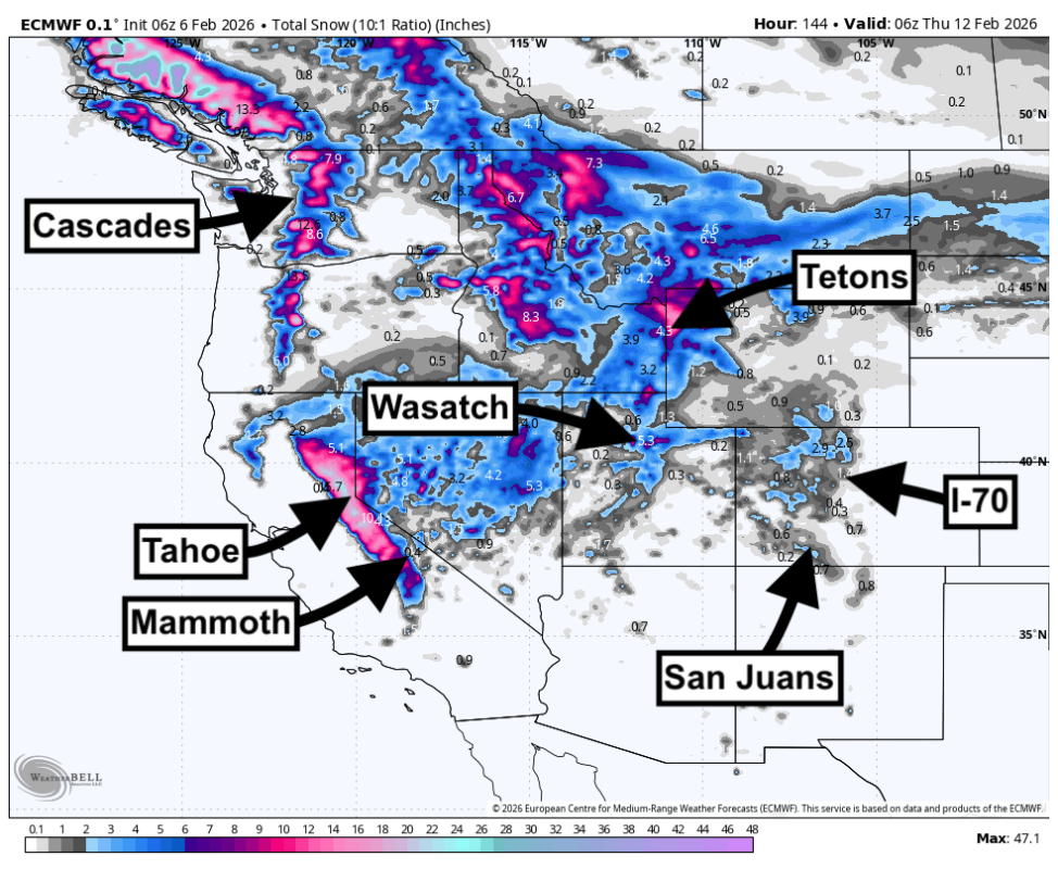
Powderchasers/WeatherBell
A warm ridge holds through Friday, February 6, then a wetter pattern rolls in this weekend with a sharp west-to-east push of moisture and wind.
The Pacific Northwest gets the first hit, and the best results stay centered on higher terrain where snow levels can keep up. Expect dense, heavy snow early, then better-quality snow as colder air lowers snow levels through Sunday night and into Monday.
Early next week shifts the focus south and inland. The Sierra looks set for a cleaner, more powder-friendly refresh Monday night into Wednesday with colder temperatures and improving snow ratios, and the Wasatch follows with a stronger midweek push that peaks Tuesday night into Wednesday.
Confidence remains highest in the timing of the pattern change and the cooling trend, with the biggest uncertainty tied to where the heaviest bands set up and how long the midweek snow holds on.
Ski Resort Snowfall Totals (Feb 7-11, 2026)
- Grand Targhee, WY: 6-11 inches
- Mt. Bachelor, OR: 7-11 inches
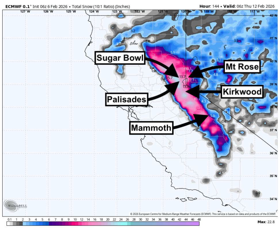
- Kirkwood, CA: 6-12 inches
- Mammoth, CA: 7-13 inches
- Solitude, UT: 7-13 inches
- Snowbird, UT: 7-14 inches
- Brundage, ID: 8-14 inches
- Brighton, UT: 7-14 inches
- Alta, UT: 7-14 inches
- Timberline, OR: 12-20 inches
Photo: Courtesy Timberline Lodge
Daily Storm Chase Recommendations
Each day’s snowfall range combines the previous night (4 pm–8 am) and that day (8 am–4 pm).
- Sunday (02/08): Chase Timberline for 8-12 inches of very dense to heavy snow with gusts near 50 mph, and keep Crystal Mountain in play for 4-6 inches of heavy snow with lighter wind impact.
- Monday (02/09): Chase Brundage for 7-11 inches of heavy snow trending drier as temperatures fall, and consider Timberline for 7-11 inches with deeper storm stacking overall while strong ridge winds continue to knock snow around.
- Tuesday (02/10): Chase Mammoth for 5-9 inches of moderate to fluffy snow with light winds and cooling temperatures, with Kirkwood as a strong backup at 3-6 inches of similarly good-quality snow.
- Wednesday (02/11): Chase Solitude for 5-10 inches of moderate snow with gusts near 40 mph, with Brighton close behind at 6-11 inches where stronger gusts near 50 mph may push the best turns into sheltered aspects.
Powderchasers/WeatherBell
Extended Outlook
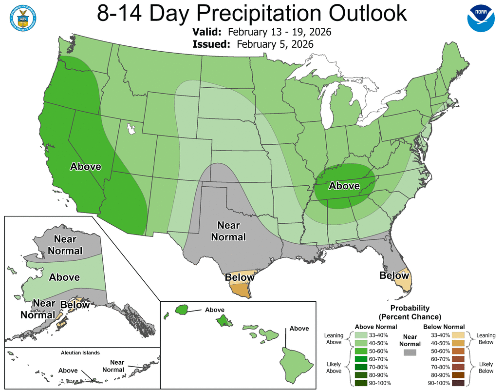
CPC
The broader pattern stays more active after midweek, with a continued signal for cooler temperatures along the West and more frequent chances for precipitation across the coastal ranges and interior mountains. Timing and placement details diverge more late week into next weekend, so expect shifts in which sub-region gets the next meaningful band. The overall trend supports additional mountain snow opportunities, with the best odds tied to periods when snow levels stay lower and winds back off enough to preserve snow quality.
Related: Pennsylvania Ski Resort To Stay Open Into May for First Time Ever
